El Niño Advisory in effect — Niño 3.4 at +2.7 °C Latest updates

Everything El Niño, in one place

The all-in-one hub for El Niño news, science and history. We track official advisories from NOAA, the WMO, Australia’s Bureau of Meteorology, Japan’s JMA, Peru’s ENFEN and agencies worldwide — and explain the science and history behind them. Every article lists its official sources.

Current ENSO status

El Niño Advisory
Phase
El Niño
Niño 3.4 anomaly
+2.7 °C
Data as of
2 Sept 2026

El Niño is strengthening, with a greater than 90% chance of a very strong event during the Northern Hemisphere fall and winter 2026-27.

Source: NOAA Climate Prediction CenterENSO Diagnostic Discussion (opens on the source’s website in a new tab) (week centred on 2 September 2026)

The Pacific right now

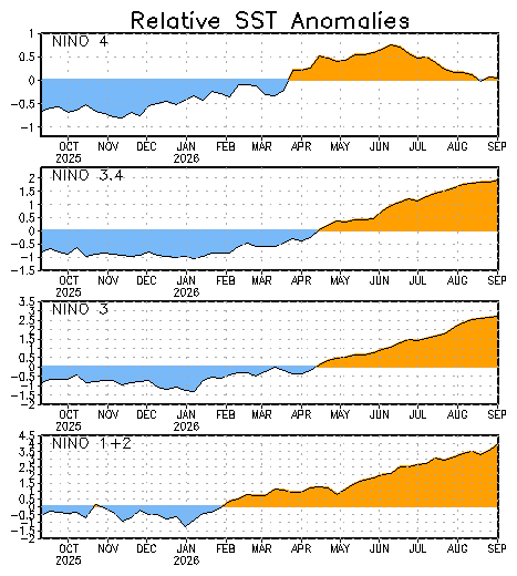
Sea surface temperature anomalies across the four Niño regions, as published by NOAA’s Climate Prediction Center and updated weekly.

Four stacked time-series charts showing sea surface temperature anomalies for the Niño 4, Niño 3.4, Niño 3 and Niño 1+2 regions over the past year, with values crossing from below normal (shaded blue) to above normal (shaded orange) during the northern spring.
Relative sea surface temperature anomalies in the four Niño regions. NOAA Climate Prediction CenterPublic domain (work of the US federal government). Mirrored .

Latest coverage

All news →
News4 min read

Somalia's Famine Risk Window Stays Open Through January, FEWS NET Says

FEWS NET's August 2026 Somalia update keeps a credible risk of Famine (IPC Phase 5) from October to January 2027, citing a moderate likelihood of extreme deyr flooding, Baidoa sorghum and maize prices up about 68 percent year-on-year, and just 404,208 people assisted in July.

  • FEWS NET assesses a credible risk of Famine (IPC Phase 5) in southern Somalia from October 2026 through January 2027 if extreme, widespread flooding materialises during the deyr season.
  • FEWS NET now projects Crisis (IPC Phase 3) outcomes through September in the Sorghum High Potential Livelihood Zone of Bay and Gedo on better-than-expected xagaa rains, but expects deterioration to Emergency (IPC Phase 4) from October.
  • According to FEWS NET, sorghum and maize prices in Baidoa are up roughly 68 percent on August 2025 and about 42 percent on the five-year average, while the Somali Shilling in Mogadishu's Bakaara market is down 27 percent on August 2025 and 33 percent on the 2021-2025 average.

1 official source cited

News4 min read

FEWS NET Sees Below-Average Harvests Across East Africa's Best Cropping Zones

FEWS NET's 11 September 2026 East Africa Seasonal Monitor reports preliminary maize yield deficits of about 28% nationally in Kenya and 43% anticipated in high-potential counties, while a well-established El Niño is expected to bring above-average October–December rains, with probabilities up to 90%.

1 official source cited

News4 min read

FEWS NET: Karamoja Crop Losses of 50-75% Hold Crisis Hunger Into January

FEWS NET says Crisis (IPC Phase 3) hunger will persist across all nine Karamoja districts through January 2027 after the driest June-September on record, with crop losses of 50-75 percent and refugee settlements deteriorating during the October-January lean season.

1 official source cited

News3 min read

Ethiopia's Kiremt Rains Rank Among Driest on Record as Meher Harvest Falters

FEWS NET reports June–September kiremt and karan/karma rainfall deficits exceeding 50 percent of average across much of Ethiopia, with the meher harvest — over 85 percent of national crop production — possibly up to 30 percent below average and Crisis (IPC Phase 3) outcomes persisting to January 2027.

1 official source cited

News3 min read

CPC's 10 September Read: 75% Chance El Niño Exceeds Every Event Since 1950

NOAA's Climate Prediction Center kept its El Niño Advisory on 10 September 2026, citing a greater than 90% chance of a very strong event in Northern Hemisphere fall and winter 2026-27 and a 75% chance of a historic October-December event at a 3-month RONI of +2.5°C or more.

1 official source cited

News3 min read

Ambovombe Floods and a Frozen Fuel Price: FEWS NET Updates Madagascar's Outlook

FEWS NET's August 2026 update keeps Toliara II and Amboasary Atsimo in Crisis (IPC Phase 3) and expects the phase to spread across Madagascar's Grand South from October, citing harvests lasting one to three months instead of six, food inflation of 10.4 percent in June and El Niño-driven rainfall delays.

1 official source cited

News4 min read

OCHA Presses UNGA Delegates for Early Money as El Niño Bears Down on Africa

UN OCHA, writing as the General Assembly convenes, says the WMO has confirmed a very strong El Niño running through late 2026 into early 2027, with up to US$100 million available from CERF and more than US$28 million already allocated for anticipatory action in seven countries.

1 official source cited

Quick answers

Full FAQ →
What is El Niño?

El Niño is the warm phase of the El Niño–Southern Oscillation (ENSO), a natural climate cycle in the tropical Pacific Ocean. During El Niño, sea surface temperatures in the central and eastern equatorial Pacific run warmer than average, the trade winds weaken, and tropical rainfall shifts eastward — changes that ripple through weather patterns worldwide.

Source: NOAA Climate.gov (opens on the source’s website in a new tab)

Is El Niño happening right now (2026)?

Yes. NOAA has an El Niño Advisory in effect. In NOAA's Climate Prediction Center weekly index, the Niño 3.4 sea surface temperature anomaly stood at +2.7 °C in the week centred on 2 September 2026. NOAA's latest diagnostic discussion states: El Niño is strengthening, with a greater than 90% chance of a very strong event during the Northern Hemisphere fall and winter 2026-27.

Source: NOAA Climate Prediction Center (opens on the source’s website in a new tab)

Why is it called 'El Niño'?

The name is Spanish for 'the boy' and refers to the Christ Child. Peruvian fishermen — from at least the 1600s — noticed a warm coastal current that arrived around Christmas each year and called it 'El Niño de Navidad'. The name entered scientific literature in 1892 through Peruvian naval captain Camilo Carrillo.

Source: NOAA (opens on the source’s website in a new tab)

What is the difference between El Niño and La Niña?

They are opposite phases of the same cycle (ENSO). El Niño means warmer-than-average sea surface temperatures in the central/eastern tropical Pacific with weakened trade winds; La Niña means cooler-than-average temperatures with stronger trade winds. Their global weather effects are roughly opposite.

Source: NOAA Climate.gov (opens on the source’s website in a new tab)

How often does El Niño happen?

Irregularly, every two to seven years. A typical El Niño develops in Northern Hemisphere summer or autumn, peaks around November–January, and decays by spring, lasting about 9–12 months in total. Since 1950, NOAA's records show 28 completed El Niño events of varying strength, with a 29th under way in 2026–27.

Source: NOAA Climate Prediction Center (opens on the source’s website in a new tab)